


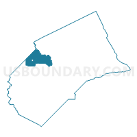
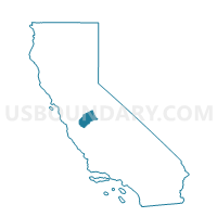
Voting District 40345, Merced County, California
About
Outline

Summary
| Unique Area Identifier | 535149 |
| Name | Voting District 40345 |
| County | Merced County |
| State | California |
| Area (square miles) | 74.65 |
| Land Area (square miles) | 71.45 |
| Water Area (square miles) | 3.19 |
| % of Land Area | 95.72 |
| % of Water Area | 4.28 |
| Latitude of the Internal Point | 37.26868980 |
| Longtitude of the Internal Point | -120.93543050 |
Maps

Graphs
Select a template below for downloading or customizing gragh for Voting District 40345, Merced County, California


Neighbors
Neighoring Voting District (by Name) Neighboring Voting District on the Map
- Voting District 40360, Merced County, CA
- Voting District 40450, Merced County, CA
- Voting District 40530, Merced County, CA
- Voting District 40531, Merced County, CA
- Voting District 50575, Merced County, CA
- Voting District 50580, Merced County, CA
- Voting District 50585, Merced County, CA
- Voting District 50590, Merced County, CA
- Voting District 50595, Merced County, CA
- Voting District 50970, Stanislaus County, CA
- Voting District 50980, Stanislaus County, CA
- Voting District 50985, Stanislaus County, CA
- Voting District 51055, Stanislaus County, CA
Top 10 Neighboring County Subdivision (by Population) Neighboring County Subdivision on the Map
- Merced CCD, Merced County, CA (99,537)
- Newman CCD, Stanislaus County, CA (12,321)
- Hilmar-Irwin CCD, Merced County, CA (9,905)
- Gustine CCD, Merced County, CA (7,835)
Top 10 Neighboring Place (by Population) Neighboring Place on the Map
Top 10 Neighboring Elementary School District (by Population) Neighboring Elementary School District on the Map
Top 10 Neighboring Secondary School District (by Population) Neighboring Secondary School District on the Map
Top 10 Neighboring Unified School District (by Population) Neighboring Unified School District on the Map
- Los Banos Unified School District, CA (39,469)
- Newman-Crows Landing Unified School District, CA (13,180)
- Hilmar Unified School District, CA (9,898)
- Gustine Unified School District, CA (8,709)
Top 10 Neighboring State Legislative District Lower Chamber (by Population) Neighboring State Legislative District Lower Chamber on the Map
Top 10 Neighboring State Legislative District Upper Chamber (by Population) Neighboring State Legislative District Upper Chamber on the Map
Top 10 Neighboring 111th Congressional District (by Population) Neighboring 111th Congressional District on the Map
Top 10 Neighboring Census Tract (by Population) Neighboring Census Tract on the Map
- Census Tract 35, Stanislaus County, CA (10,720)
- Census Tract 20, Merced County, CA (7,835)
- Census Tract 9.01, Merced County, CA (3,970)
- Census Tract 4.01, Merced County, CA (1,834)
- Census Tract 34, Stanislaus County, CA (1,601)